Monday, October 24, 2016

Love Lake Tahoe!

We took the scenic route from Humboldt County across the state to Lake Tahoe, on the border with Nevada--a beautiful drive! We passed several other lakes on the way, with cute vintage cabins on the lake shores--and we found gas for only $2.35, which we thought was relatively unbelievable for California! (We also found some delicious root beer floats at reasonable prices, one of our trademark treats during this Epic Journey.) We camped in Truckee, arriving just at dark but after the RV park office was closed, so I (Carol) had to go knock on the door of another RV and ask them for the code to get into the bathrooms. But other than that, it was a very quiet and clean campground and we had a good night's sleep.

Other than seeing Lake Tahoe for the first time, we didn't have much of a plan for the next couple of days, and our expectations weren't that high. Since it's a big ski resort area, we were a little afraid that it would be filled with "yuppies," high-priced restaurants and trendy upscale stores--the type of place that we generally don't like. It was only about a half hour's drive from Truckee down to the lake, or Big Blue as they call it here. Our first glimpse was favorable. It's a huge, gorgeous lake surrounded by impressive mountain peaks, many with snow on them already. Although most of the trees here are big evergreens, there are also some deciduous trees and the fall colors were eyepopping next to the blue of the lake. It's a good time for us to be here, right between their busiest seasons of summer and the winter ski season.

Lake Tahoe with snow-covered mountains in the back ground.

Beautiful fall colors at Lake Tahoe.

We stopped at the Visitor's Center in Tahoe City to get maps and information, and the man behind the counter was very helpful. We had decided we wanted to drive around the lake, which is about 70+ miles, so he gave us tips about good places to stop for the view and photos. He also said that Tahoe City had a nice promenade along the shore and that we should go down there for a walk before setting out on our long drive. He also told us which campgrounds were still open (not many!). Tahoe City was not too big a town and, while it did have its share of trendy restaurants and shops, they were pretty cute and we actually liked the place. We did go down and walk along their lovely promenade and took a bunch of pics. Then we went to one of the trendy restaurants and had pancakes on their outdoor porch. Very nice.

View from the promenade.

Another view from the promenade.

Next we drove about 8 miles along the lakeshore to grab a campsite at Sugarpine Point State Park, the nearest open campground. The park and campground seemed deserted as we drove in and we were afraid it wasn't really open, but it turned out that they keep one section of campsites open. Lots of sites were available, with only a couple of tent campers there. Nice peaceful place with huge pine trees all around. We left a tablecloth on the table to claim our spot, and then headed out to begin our drive around the lake, starting in the southerly direction from our campground on the west shore.

Jack showing the size of the huge sugar pines trees in the campground. 
Their pine cones, shown on the ground, are the size of footballs. 

The traffic wasn't bad at all--another good thing about being here at this time--but almost immediately we ran into road construction delays, which was a little frustrating. But we got to see all the views we wanted, eventually. The first stop that the Visitor Center guy had recommended was a nice park area with fall colored bushes and great lake views, so we took a bunch of photos there. The area is so pretty that you just want to keep snapping photographs of everything. Around every curve is another marvelous view.
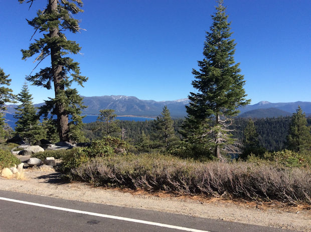
View of Lake Tahoe from west side.

Another view of Lake Tahoe from the west side.

The road began to climb up a steep mountain and then the views got really breathtaking! At one point we were driving over a skinny one-lane road with steep cliffs dropping down to the water several hundred feet on both sides! That took our breath away for sure! It would have been better without all the construction stops, but nevertheless this is some of the most gorgeous scenery in the world. It definitely exceeded our expectations!

Emerald Bay and Fannette Island, the only island in Lake Tahoe.

And of course, with Jack along, there have to be fish in the story. The kokanee salmon are born in the mountain streams and move out into the lake to live, coming back into the streams where they were born to spawn, just like the oceangoing salmon. We just happened to be here during spawning season and our helpful guy had told us we should stop at Taylor Creek to see the kokanee--a great suggestion. We stood on a bridge and watched the big schools of red kokanee being chased by the mergansers, a type of redheaded duck that eats fish. One merganser was very determined, chasing the fish both on the surface and under the water. The stream was so clear that we could see everything as it played out. The duck chased and chased, and obviously got frustrated. But then he finally caught a fish and gobbled it down. It looked too big to fit into his small throat, but he managed!

The merganser (in blue water) is chasing the salmon (red fish in lower right).

Then we walked the nature trail by the stream and discovered a really neat building--a science encounter center where they've diverted part of the stream into the building, which has big glass walls that allow you to watch the kokanee and other stream life. The male kokanees turn red when they get ready to spawn and their jaws get very hooked. After they spawn, they die and provide food for other creatures. This was a really interesting place and we spent a lot of time here.

Up close with a male kokanee salmon. Note the big hooked jaw.

In fact, between the fish-watching and the construction delays, we realized that we weren't going to make it around the lake before dark, so we backtracked to our campground, taking lots of photos along the way. At one point we passed Emerald Bay, which has the only island in Lake Tahoe--we got some good pics of that, since the sun was starting to go down.

Another view of Emerald Bay with Fannette Island.
There is a beautiful Scandinavian chalet (former summer home) on the top of the island.

We had a good night's sleep--no bears visited--and got an early start the next morning. We'd decided to start driving in the other direction, north, and check out some more stops that our helpful guy had suggested. We crossed over the Nevada state line and ended up at a high summit, at about 8500 ft, which offered some great panoramas of the lake below. A nice fellow offered to take a photo of us both. Jack got more and more artsy with his photos!

Jack and Carol with Lake Tahoe far below.

Lake Tahoe from Nevada side.

Finally we felt that we had enough photos of this gorgeous place, and we decided at that point to leave the lake and head on over toward Yosemite, since our camping reservation in Yosemite Valley started on Sunday, Oct 23. We had to climb some big mountains to get there, since we wanted to enter Yosemite through Tioga Pass on the eastern side, which sometimes closes due to snow in October. More to come on that part of the journey.

Friday, October 21, 2016

Eureka, Redwoods, and Pot

It's been a week since our last blog! Yikes! When we left you last time, we were hunkered down in a bad storm on the Oregon coast. Fortunately no trees blew down on us, but it blew the paint right off our RoadTrek! Some areas had tornados just after we passed through. Can you believe this? We're definitely due for a major paint job when we get back. (New windshield still looks good though!)

Paint damage due to high winds and lashing rain. Poor RoadTrek!

Although it was still raining when we left the campground on Friday to complete our Oregon coastal drive, it wasn't blowing nearly as bad as it was on Thursday. We still had the southern portion of the coast to drive, and it was just as spectacular as the rest of it. We stopped at several view spots to grab pics of the other-worldly rocky structures in the ocean, being lashed by rain, wind and waves. We can understand how these natural sculptures are formed! One spot had a huge rock arch with waves surging through the arch. We got tired of saying "Wow!" all the time.

Large shark fin?

Trees grow on rocks in ocean. How about that?

There's a big hole in that rock.

We finally said goodbye to Oregon, and crossed over into northern California. We were headed to Eureka to visit some good friends of ours who we hadn't seen in a bunch of years. To get there, we drove through part of Redwoods National Park (actually it's a national park that cooperates with several California state parks to form one big beautiful park). We drove for miles through one section of beautiful redwoods along highway 101. Unfortunately due to the rain and taking our time driving, we didn't have time to stop and take photos, as we needed to get to Eureka well before dark. But we promised ourselves we'd definitely see more redwoods and take photos later while in the area.

Our friend Norm has lived and had his solar business in Eureka for over 40 years. (Both of us used to work with Norm many years ago.)  We pulled into his driveway around 5 pm, and he met us riding on a Segway! Carol got VERY excited because she's had a longstanding desire to ride a Segway but has never had the opportunity. Norm gave her a quick lesson and she executed a few maneuvers in his driveway. Carol: AWESOME! I WANT ONE!

Carol riding Norm's Segway--on Carol's wish list. 

Jack getting advice from Norm about off-grid solar power.

After oohing and aahing over the Segway (Norm had to show us how well he can maneuver it--the thing is uncanny!), we sat and yakked for awhile, catching up on the last 10 years or so--lot of water over the dam. We made plans to get together the next day for brunch. Then we headed on to the next town down, Del Rio, to Norm's RV park which is managed by his ex-wife Sharon, also a dear friend of ours. The RV park is right on the Eel River--Sharon met us as we drove in and escorted us to our site, right beside her RV. It's exciting to see her after so long. We also met her friend Lee, and Huckleberry, a huge, friendly (and always hungry) Labrador. (Lee had assembled dinner for us all--meatloaf and mashed potatoes--what a guy!)

Carol and good buddy Sharon.

Lee (with guitar) and Huckleberry (the dog).

We spent a pleasant night there, and had coffee with Sharon in the morning, and then went to meet Norm the next day for brunch/lunch, and then went to see his solar business, Six Rivers Solar. He's won a lot of awards for his business and it was exciting to finally see the place. He is definitely a solar power pioneer! Seems that there's nothing he doesn't know about that business.

Sharon makes a great cup of coffee.

We took Sharon out for dinner that night at a historic restaurant/inn in Scotia, an interesting nearby town, with a long logging history. The food was fabulous! (In fact, we've been eating very well ever since we got here.) It was wonderful hanging out with old buddies again. Sharon has taken up the ukelele and she and Carol spent an afternoon picking and singing duets--lots of fun! Great visit!

Hated to leave, but the redwoods were calling us. First we needed to get the oil changed in the van, and we found a nice place nearby to get that done. (We saw an interesting phenomenon while waiting on the van--a rainbow that went across a wooded hill, rather than being in the sky. Weird.) The van was certified A-OK and we headed south, toward The Avenue of the Giants, a 32-mile-long scenic byway south of Eureka that is in the largest remaining old-growth coastal redwood forest.

We didn't expect to be as gobsmacked as we were by the redwoods. These trees are just breathtakingly magnificent. We've both seen a few redwoods before, but not in this quantity. They're huge, the tallest living creatures, and very, very old. Some are thousands of years old. The Avenue of the Giants turned out to be an interesting combo of pristine, primeval redwood forest and kitschy, vintage (circa 1950s) touristy stuff. We ogled the trees (the sun came out for this drive!), and stopped at most of the touristy stops too. Like the cute little houses made from a single redwood log, or the 20-foot room built under the stump of a dead redwood, or the drive-through tree. Our van couldn't fit through this drive-through tree, but we watched (and photographed) a car drive through it, and then we got a passerby to photograph us strolling through it. Too much fun!

Carol with a majestic giant.

Jack with a double-trunked redwood (starts out as one big trunk at the bottom and then separates into two).

Roadtrek doesn't fit but Jack and Carol do.

This Toyota fits...barely

Carol in the treehouse she always wanted, made from one log.

We finally had to stop at a campground when it got dark (big trees in the campground too). We planned to get most of the way to Lake Tahoe, our next destination, the next day, but that was not in the cards. We drove south on Highway 101 for about an hour and then came upon a line of cars stopped dead. We sat there for a while, thinking it was yet another "road work" stop, but then we saw people getting out of their cars and wandering down the road out of sight. Some of them eventually came back and we asked them what was going on. It turned out that an oil tanker had just turned over about a half mile up the road from us and had spilled oil all over the world. We wouldn't be moving for 4 to 5 hours! This is one of those times when we're really glad to be in our RoadTrek! We turned on the generator and worked on our laptops, had a frig full of snacks and sodas, and our own bathroom. So no worries! We chatted with some of the other folks in line with us. And finally the CHP vehicle came through with his loudspeaker saying to get ready, that we'd be moving shortly. It was about 4 or 5 hours, sure enough.
We were stuck in this line of traffic for about 5 hours, while Hazmat team cleaned up spilled oil off the road. 101 was closed for a long time.

We stopped for gas in the little town of Garberville and were amazed to see the streets filled with "hippies"--or that's what we would call them--a flashback to the 1960s. Unkempt, unwashed people with unusual, not very clean clothing, lots of rasta hair, and with a very spaced out look in their eyes. Also many unusual vehicles, like painted-up old schoolbuses. And LOTS of young hitchhikers. They were EVERYWHERE in this town, filling up the minimart where we got our gas, lining the sidewalks, and hitchhiking on every road. Carol did a little research and found that this is due to this place being the world capital of pot growing (i.e., marijuana, mary jane, hemp, weed, ganja... whatever you like to call it). In this county, Humboldt, growing pot is the main industry and it is very lucrative. The marijuana grown here is supposed to be the best in the world, and brings a premium price. These flower children come here from all over the world to live in the redwood forest and smoke the fabulous (to them) weed. We photographed one of the strangely decorated buses at a motel where we stayed for the next two nights. (Carol got loaded up with book editing so we did some down time at a motel for her to catch up.) No pot smoking for us...

Quite the van, right out of the sixties. But the occupants looked like they were in their twenties.

In the next installment, we visit Lake Tahoe--yet another incredibly beautiful part of our country!


Thursday, October 13, 2016

Coasting in Oregon

After getting the van windshield replaced, our plan was to drive Highway 101 down the entire Oregon coast over a 3 or 4 day period, ending up in Eureka, CA on Friday afternoon to visit friends there. We spent Monday night in a motel in Vancouver, WA and caught up on our blog, since we had been way behind on it. Tuesday we headed west, following the course of the mighty Columbia River, all the way to the coast.

Since we are big fans of Meriwether Lewis and William Clark, our first stop on the coast was the Fort Clatsop Visitor Center, part of the Lewis and Clark National Historic Park. Here they have a reproduction of Fort Clatsop, the structure that the Corps of Discovery built near the mouth of the Columbia to winter over in, before they started their long journey home. It's in a magical forest with huge, moss-covered trees. We walked the short trail through the trees down to the site of their canoe landing and tried to imagine what it was like for the Corps being here, having made it all the way to the Pacific Ocean. They had a very hard winter here--nothing but cold rain and wind pretty much all the time.

Fort Clatsop reproduction in Lewis and Clark National Historic Park.

Jack with Sitka spruce tree in forest surrounding Fort Clatsop site.

As it turns out, the Clatsop Tribe of native Americans had already been here for hundreds of years and had been regularly trading furs with the British and others (they called them all "cloth men" because of the clothes they wore). The Clatsops were a bit puzzled by the Lewis and Clark expedition, since they didn't have much to trade with by that time, but the Indians helped Lewis and Clark tremendously by providing them with food and advice for surviving the winter. And as we found out, the Corps rewarded them by stealing one of their beautifully carved and extremely seaworthy canoes (that were sacred to the tribe) to use on the homeward journey. Oh well, at least when the soldiers left Lewis signed over Fort Clatsop and the furniture inside to their chief, and he lived there with his family for a few years.

Leaving the National Historic Park, we drove south toward the next town, Seaside, and found a campground nearby. We were craving some seafood and drove into town (very quaint and beachy) in search of clam chowder. We found it at Norma's, a local seafood favorite cafe, and it was definitely tasty!

We got up relatively early the next day so we could drive on down to the next town, Cannon Beach, and photograph it. The weather was going to turn nasty fairly soon and we wanted to take some photographs at this most-photographed spot on the Oregon coast, and also we wanted to beat the crowds, if any. We were almost the first ones at Ecola State Park, a high point overlooking Cannon Beach which is a well-known spot for taking photographs. It was a beautiful morning and the scenery is spectacular indeed from this spot. There were even some ripe marionberries up there, which Jack had to pick and try (sour).

View looking down on Cannon Beach from Ecola Point.

Small sailboat and rock with historic lighthouse on top, viewed from Ecola State Park.

Jack berry-picking.

As more people began to arrive in the parking lot, we started to get hungry and decided to look for some donuts down in Cannon Beach proper. We found a nice bakery and had coffee and donuts on their porch, while being besieged by crafty sparrows who snatched crumbs from under our feet. We then walked to a beach access road and walked on the beach awhile, taking more photos from this lower perspective. The icon of Cannon Beach is Haystack Rock, a huge basalt monolith right in the surf, that is the home of many seabirds and other sea creatures. It is very photogenic!

Haystack Rock, from close up.

Haystack Rock, from farther away. It's hard to stop taking pictures of it!

One more: Jack's artsy view with sand dune...

As we were making our way off the beach back to the van, we saw a marriage proposal written in the sand: "DOM WILL YOU MARRY ME?" in neat letters about 3 feet tall. Certainly a romantic spot!

The town is very cute too. It's a classy beach town, with historic buildings, cool architecture, and lots of art galleries. It is very popular and gets crowded during the summer season, but this is a good time to be here--nice and relaxed (but still quite a few people, especially around lunch time). Whale Park at one end of town has a statue commemorating the dead beached whale that Lewis and Clark came here to see (they took Sacagawea with them on that trek, apparently the only time she got to see the ocean).

Whale Park in Cannon Beach.


The Cannon Beach Post Office is beachy too.

(Oh, one other thing about Cannon Beach: the day before we got here, a surfer was attacked by a shark and had to be airlifted out due to extensive leg injuries. The guy was a trauma nurse and knew what to do--he punched the shark and it let him go, and then he had his buddies use the surfboard leash as a tourniquet while they waited for the ambulance. He's had surgery and is recovering.)

We got back on 101 and continued our drive south, feeling like we were working against time, since we knew a bad storm was heading our way and the next several days would be nothing but rain and wind. We stopped at most of the overlooks and took a bunch of photos.

Admiring yet another scenic coastal feature.

Typically scenic spot.

Another shot of that old lighthouse from Ecola Point.

What a view from this place!

The thing that surprised us both about the Oregon coast is the hundreds of miles of wide, white, soft sandy beaches! Most of the photos we'd seen of this area were green rocky cliffs with big waves beating on them, and lots of big rocks, like Haystack Rock, just offshore. These views do exist, but the beaches themselves are some of the prettiest beaches we've seen. And every 10 miles or so is a cute, quaint old seaside town or village, each with its own distinct character and feel. You could spend a lifetime driving this coast and not see it all!

At one viewpoint turnout, a steep rocky cliff dropped straight down to the surf about 1600 feet below. The explanatory plaque there said that men had quarried rock off the cliff face and used it to build a stone wall to hold up the cliff side, to support the road. Quite an engineering feat from the looks of it!

The engineer in us couldn't help admiring this huge rock wall construction.

The town of Tillamook is noted for its cheese manufacturing operation, and they offer tours and free samples, so we had to stop. They are a major cheddar brand and their cheese is great! We bought some.

A fun stop to watch people making cheese and sample several varieties.

Our last stop before camping for the night was Cape Kiwanda at the little town of Pacific City, which is noted for a fleet of fishing dories that launches and lands through the surf on the beach, to make their way out into the open ocean to fish for salmon, Dungeness crab, and various rock fish. They've been doing this for a long time. People drive their vehicles onto this beach, as is obvious from the photo, including trucks pulling dories on trailers. Signs warn to watch for high-speed dory boats landing through the surf. Unfortunately, we didn't see any.

Cape Kiwanda, launching spot for a fishing dory fleet. Can you believe these wide, sandy beaches? They're everywhere!

Cape Kiwanda has its own Haystack Rock, with a little arch in it, no less!

We camped at a nearby state park, and the rain began just about the time we got settled in. We were lulled to sleep by the sound of rain on the roof.

It was pouring down in the morning, so we resolved to get as far as we could down the coast without stopping too much, since we didn't think we'd be able to see very much through the rain and mist. We did get a few photos, however, one dramatic one of a lighthouse perched on the side of a big rock head in the surf. The surf looked quite different today than it did yesterday. As we got farther south we came to the National Dunes Recreation Area. Another surprise for us: we didn't associate Oregon with giant sand dunes, but it sure has them! Miles and miles of them! And yet another surprise was the cranberry bogs along the southern coast. (Oregon is known for its cheese, hazelnuts, and cranberries!)

Note the fragile-looking little lighthouse clinging to the side of the rock in the center of the photo. It has a bright light though, and does its job well!


Stormy view from one of the overlooks. Quite a bit different from yesterday!


Huge sand dunes along many miles of the southern coast. The rain had let up a little at this point.

The rain and wind got much worse in midafternoon, and we passed a serious wreck, which convinced us to stop for the night at the next campground, which was a KOA (with Wifi, yay). We're currently hunkered down--wind advisory here says gusts up to 80 mph, yikes. Tomorrow (Friday) will also be rainy but wind not as bad so we will skedaddle on down the coast and see if we can get to Eureka, CA. We were going to stop and visit the redwoods but we may have to wait on that a few days. Another nasty storm is heading this way on Saturday.