Other than seeing Lake Tahoe for the first time, we didn't have much of a plan for the next couple of days, and our expectations weren't that high. Since it's a big ski resort area, we were a little afraid that it would be filled with "yuppies," high-priced restaurants and trendy upscale stores--the type of place that we generally don't like. It was only about a half hour's drive from Truckee down to the lake, or Big Blue as they call it here. Our first glimpse was favorable. It's a huge, gorgeous lake surrounded by impressive mountain peaks, many with snow on them already. Although most of the trees here are big evergreens, there are also some deciduous trees and the fall colors were eyepopping next to the blue of the lake. It's a good time for us to be here, right between their busiest seasons of summer and the winter ski season.

Lake Tahoe with snow-covered mountains in the back ground.

Beautiful fall colors at Lake Tahoe.

View from the promenade.

Another view from the promenade.

Jack showing the size of the huge sugar pines trees in the campground.
Their pine cones, shown on the ground, are the size of footballs.
The traffic wasn't bad at all--another good thing about being here at this time--but almost immediately we ran into road construction delays, which was a little frustrating. But we got to see all the views we wanted, eventually. The first stop that the Visitor Center guy had recommended was a nice park area with fall colored bushes and great lake views, so we took a bunch of photos there. The area is so pretty that you just want to keep snapping photographs of everything. Around every curve is another marvelous view.
View of Lake Tahoe from west side.

Another view of Lake Tahoe from the west side.

Emerald Bay and Fannette Island, the only island in Lake Tahoe.
And of course, with Jack along, there have to be fish in the story. The kokanee salmon are born in the mountain streams and move out into the lake to live, coming back into the streams where they were born to spawn, just like the oceangoing salmon. We just happened to be here during spawning season and our helpful guy had told us we should stop at Taylor Creek to see the kokanee--a great suggestion. We stood on a bridge and watched the big schools of red kokanee being chased by the mergansers, a type of redheaded duck that eats fish. One merganser was very determined, chasing the fish both on the surface and under the water. The stream was so clear that we could see everything as it played out. The duck chased and chased, and obviously got frustrated. But then he finally caught a fish and gobbled it down. It looked too big to fit into his small throat, but he managed!

The merganser (in blue water) is chasing the salmon (red fish in lower right).
Then we walked the nature trail by the stream and discovered a really neat building--a science encounter center where they've diverted part of the stream into the building, which has big glass walls that allow you to watch the kokanee and other stream life. The male kokanees turn red when they get ready to spawn and their jaws get very hooked. After they spawn, they die and provide food for other creatures. This was a really interesting place and we spent a lot of time here.

Up close with a male kokanee salmon. Note the big hooked jaw.
In fact, between the fish-watching and the construction delays, we realized that we weren't going to make it around the lake before dark, so we backtracked to our campground, taking lots of photos along the way. At one point we passed Emerald Bay, which has the only island in Lake Tahoe--we got some good pics of that, since the sun was starting to go down.

Another view of Emerald Bay with Fannette Island.
There is a beautiful Scandinavian chalet (former summer home) on the top of the island.
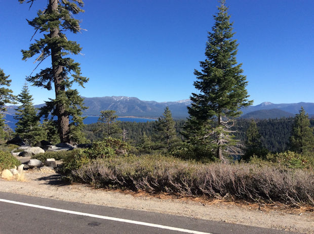
We had a good night's sleep--no bears visited--and got an early start the next morning. We'd decided to start driving in the other direction, north, and check out some more stops that our helpful guy had suggested. We crossed over the Nevada state line and ended up at a high summit, at about 8500 ft, which offered some great panoramas of the lake below. A nice fellow offered to take a photo of us both. Jack got more and more artsy with his photos!

Jack and Carol with Lake Tahoe far below.

Lake Tahoe from Nevada side.
Finally we felt that we had enough photos of this gorgeous place, and we decided at that point to leave the lake and head on over toward Yosemite, since our camping reservation in Yosemite Valley started on Sunday, Oct 23. We had to climb some big mountains to get there, since we wanted to enter Yosemite through Tioga Pass on the eastern side, which sometimes closes due to snow in October. More to come on that part of the journey.
I thought you would enjoy the lake. They say the water is so pure you can see a 12" plate in 30 feet of water. I remember driving that section of road without any sides. It's not for the faint of heart that's for sure. When I was out there with June we took the paddle-wheeler ride around the lake and into Emerald Bay. I'm surprised how low the lake is, but we were there in May. Did you have your root beer float at the little ice cream shop on the main street in Truckee? June liked that place so much we went there twice. Quite the feat considering we were staying in South Lake Tahoe.
ReplyDelete